
PORT ANGELES — The ski season at Hurricane Ridge will come to an end Sunday after only a month of operating due to a lack of snow.
“The turnout was really good for March on the first day that we were open,” said Danielle Lawrence, a volunteer with the Hurricane Ridge Winter Sports Education Foundation, which operates the ski area.
“After that, it kind of slacked off,” she said.
March is typically slow for skiing, Lawrence said, because most people have moved on to spring sports. But the foundation was able to operate for four out of the five weekends in March, and youth skiing classes scheduled for January and February were able to be rescheduled.
“A lot of people were incredibly understanding and flexible,” Lawrence said.
The foundation had to sit out the second weekend in March due to weather conditions at the ridge, but it will be open for the final weekend, Lawrence said. An Easter egg hunt will be conducted at the ridge today from 11 a.m. to 1 p.m., Easter bunny included.
But whether there’s snow or not, the season ends on March 31 every year under the agreement with Olympic National Park.
Hurricane Ridge Road will remain open to the public — weather permitting — on Monday, but ONP’s maintenance crews are needed elsewhere in the park to prepare for the upcoming tourist season.
“Olympic National Park’s road crew — composed of fewer than 10 employees — dedicates the early spring season to reopening many of the park’s roads and campgrounds,” park spokesperson Molly Pittman said in an email. “This massive effort requires a full team to remove the debris, trees, and snow that have accumulated throughout the winter.”
With the stalled season, the foundation didn’t raise as much money as it typically does from the sale of lift passes, but Lawrence said the organization is doing well.
“We have been blessed with various grants, so we are doing fine financially,” Lawrence said. “We thank all the people who came up even though conditions weren’t stellar. We hope people had a good time and we look forward to seeing them next year.”
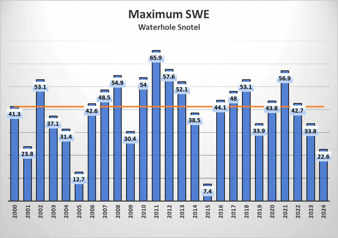
This isn’t the first year that the ski season has been lost due to a lack of snow, but 2024 is among one of the lowest snow-level years since 2000, according to local data.
“This is a relatively abnormal year,” said Bill Baccus, a physical scientist with Olympic National Park. “It’s not a 2015, which was a really standout year, but I would say this is a pretty low year.”
According to data from the U.S. Department of Agriculture’s SNOTEL snow monitoring system, snow water equivalent levels — the amount of water produced when the snow melts — at the Waterhole monitoring station near Hurricane Ridge showed a maximum of 22.6 inches for 2024.
The lowest year since the Waterhole station began monitoring in 2000 was 2015, with a total snow water equivalent of 7.4 inches, followed by 2005, with 12.7 inches.
Data for the Cox Valley Snow Course — a record which Baccus said correlates strongly with Waterhole — dates back to 1968, and that data shows 2024 is the fifth lowest year on record, with 2015, 2005, 1981 and 1977 having lower amounts.
This year’s low snow level has been attributed to the El Niño Southern Oscillation, a weather phenomena over the Pacific Ocean that typically brings colder weather to the southern parts of the U.S. and warmer weather to the Northern parts. But Baccus said there’s been a downward trend in overall snow levels for the region, which can likely be attributed to climate change.
“That is what you would predict,” Baccus said of the declining snow levels. “The reason you get less snow is because you have warmer temperatures.”
Baccus said the Olympic Mountains are fairly low elevation and are impacted by a marine environment which makes temperatures in the mountains warmer than they might be elsewhere. The average winter temperature at Hurricane Ridge is 30 degrees Fahrenheit, just below freezing.
“You just don’t have a lot of temperature to play with before you move from a snow regime to a rain regime,” Baccus said.
That can be a problem for communities that rely on winter snowpack for their water.
“That is the big conundrum in the Pacific Northwest, our ecosystems and infrastructure rely on that reservoir of water that’s traditionally been held in the mountains,” Baccus said. “It’s a statewide issue and something a lot of people are looking really closely at.”
There’s also a concern for increased fire danger. The Department of Natural Resources has said that 2023 had the second-highest number of ignitions in state history and has warned of increased fire danger annually.
A drought was declared in July 2023 for parts of 12 counties, including most of Clallam County and parts of Jefferson County, and it has yet to be lifted.
A low snowpack typically means snow melting earlier, and that can lead to plants and soils drying out, which can increase fire danger.
But Baccus said there isn’t necessarily a strong correlation between low snowpack and an early start to peak fire season. Spring and summer weather is a better indicator of fire danger. A lack of summer rainfall and warm temperatures are more likely to increase fire danger than a low snowpack and an early snow melt, he said.
“We had a pretty unprecedented period of dry weather that really caused all of that to blow up,” Baccus said of the late summer wildfires in the park that were started last year by an August lightning storm.
The low snowpack is likely to impact river flows, particularly in late summer. An early snowmelt also can lead to low river levels in late summer, particularly without any recharging rain events.
“We don’t have a good way of predicting how much rain we’re going to get,” Baccus said. “It’s really temperatures and sun in the spring and early summer that are going to control summer flows.”
________
Reporter Peter Segall can be reached at peter.segall@peninsuladailynews.com.
