UPDATE: Our weather today — calmer but unsettled, according to forecasters

From http://www.komonews.com/weather/radar/ (Click on image to enlarge)

From http://www.komonews.com/weather/radar/ (Click on image to enlarge)

FROM KOMO 4 NEWS:

A much calmer day is on the way today. There will be some showers and sunbreaks and even a chance for a thundershower.

Highs today will hit the upper 60s.

There is also a chance for a shower or two in the fire zone east of the mountains. Cooler temps, higher humidity and calmer winds will also being helping firefighters.

Monday we are also going to be mostly cloudy. Showers will linger across western Washington with highs in the upper 60s.

We get a better chance of sunbreaks on Tuesday with highs in the low 70s, but still can’t rule out a shower.

The pattern doesn’t change much midweek. A strong onshore flow will keep bringing the mostly cloudy conditions with showers at times. Highs will hover in the upper 60s.

FROM KING 5 NEWS:

TODAY:

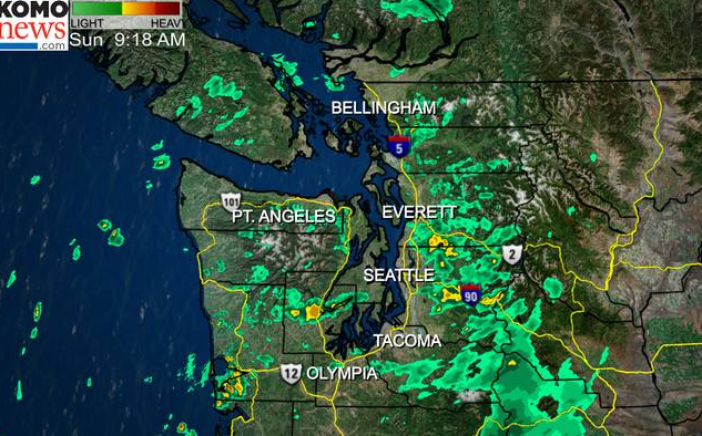
Puget Sound Forecast: Expect showers and a few embedded thundershowers. The best chance for thunder and lightning coming in the morning. A few afternoon sunbreaks are possible. Highs in the upper 60’s. Winds will be calmer with wind from the south over Puget Sound and Hood Canal 5-15 mph.

Coast Forecast: Mostly cloudy with a good chance of showers and morning thunderstorms. Highs in the mid 60’s. Winds from the SW 5-10 mph.

Mountain Forecast: Rain, mixed with snow above 7,500′. Highs in the low 50’s to low 60’s at pass level. Winds from the SW 5-10 mph.

Eastern Washington: Mostly cloudy with showers and thunderstorms. The best chance for storms is the afternoon. Breezy near the Idaho border. Highs in the 60’s and 70’s.

WEATHER DISCUSSION:

Coming off of a wild weather day, things will be much calmer for your Sunday. The main storm is gone, but a trough of low pressure lingers in the Northwest much of this week leaving us with frequent chances for showers. It’s a pattern that rivals that of late September or October.

Pockets of instability may generate some morning rumbles of thunder, especially over the south sound. Showers look to break up a bit this afternoon along with a few sunbreaks. Temperatures remain below average with highs ranging from the mid 60s to near 70. Our average high for this time of the year is 75° at Sea-Tac.

A reinforcing front approaches late Monday with increasing rain and wind Monday afternoon through Tuesday morning. Highs all next week will range from the mid 60s to near 70, so it will be a cool start to September.

It looks like we return to drier weather toward the end of the week on Friday possibly extending into the weekend.

More in News

Ned Hammar, left, is sworn in as Port Angeles School District Position 2 director by Clallam County Superior Court Judge Simon Barnhart on Thursday as Superintendent Michelle Olsen looks on. (Paula Hunt/Peninsula Daily News)
Hammar, Hamilton sworn in to PASD board of directors

Major foundation work complete on Hurricane Ridge Middle School

Port Townsend plan may bump housing stock

Citizens concerned it may not be affordable

Port of Port Townsend reports strong revenues

Staffing changes, job vacancies contribute to net gain, official says

x
Grant funds help teen meal program at clubs

Boys, girls learning how to prepare nutritious dinners

EYE ON THE PENINSULA: Budget planning set for boards, commissions

Meetings across the North Olympic Peninsula

Donna Bower, left, and Kristine Konapaski, volunteers from the Michael Trebert Chapter of the Daughters of the American Revolution, unload one of the 115 boxes of Christmas wreaths and carry it to a waiting truck. (Dave Logan/For Peninsula Daily News)
Wreaths arrive for veterans

Donna Bower, left, and Kristine Konapaski, volunteers from the Michael Trebert Chapter… Continue reading

Coalition working to expand system

Anderson Lake section of ODT to open in ’26

Jefferson PUD cost of service study suggests increases

Biggest impact would be on sewer customers

Remains in shoe determined to belong to a bear

A shoe found earlier this week on the beach at… Continue reading

Clallam 2 Fire-Rescue personnel fight a residential structure fire in the 2000 Block of Dan Kelly Road on Wednesday. (Clallam 2 Fire Rescue)
Fire districts respond to structure fire on Dan Kelly Road

A home suffered significant damage to its roof following… Continue reading

Military accepting public comment on environmental impact statement

The U.S. Navy and U.S. Coast Guard are accepting public… Continue reading

Patrick Zolpi-Mikols, a park aide with Fort Worden State Park, gathers and removes leaves covering the storm drains after an atmospheric river rainstorm early Wednesday morning in Port Townsend. A flood warning was issued by the National Weather Service until 11:11 a.m. today for the Elwha River at the McDonald Bridge in Clallam County. With the flood stage at 20 feet, the Elwha River was projected to rise to 23.3 feet late Wednesday afternoon and then fall below flood stage just after midnight. (Steve Mullensky/for Peninsula Daily News)
Cleaning storm drains

Patrick Zolpi-Mikols, a park aide with Fort Worden State Park, gathers and… Continue reading