VIDEO — A virtual fly-through along the lower Elwha River

  • By U.S. Geological Survey via Peninsula Daily News
  • Friday, May 11, 2012 12:01am
  • News
Lidar image of a large bluff on the lower Elwha River west of Port Angeles.

Lidar image of a large bluff on the lower Elwha River west of Port Angeles.

By U.S. Geological Survey via Peninsula Daily News

THIS VIDEO SHOWS a virtual fly-through of a detailed, highly accurate three-dimensional model of the lower Elwha River just west of Port Angeles.

The video begins about 0.8 river kilometers upstream (south) of the bridge on Elwha River Road.

The virtual flight path then proceeds downstream approximately 5.5 kilometers, in a northerly direction to the mouth of the river on the Juan de Fuca Strait.

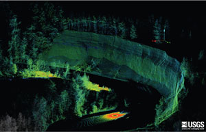
The data that are shown in the fly-through are a composite of multiple scans that were collected with a ground-based lidar (light detection and ranging) scanner, which uses high-speed laser measurements to produce highly accurate three-dimensional maps of the riparian environment.

By combining these measurements with digital images from an onboard camera, the instrument produces three-dimensional “point clouds” that can be displayed in true color.

Because the water surface is not measured by the lidar scanner, it appears black in the video.

Each of the millions of data points represents a discrete measurement with precise elevation and geographic position.

Cobble bars, gravel beds, bluffs, riverside vegetation and man-made features are all visible in the data. Each feature can be queried for size, geographic position and precise elevation.

The river system shown in this video is downstream from the Elwha and Glines Canyon Dams, both of which are being removed in the largest dam removal project in U.S. history.

For nearly a century, these dams have been preventing salmon and steelhead from accessing historic spawning habitat above the dams.

The dams have also been blocking the natural supply of sediment to the lower river, and the nearby coastal beaches.

Beginning in 2006, scientists from the United States Geological Survey (USGS) have been monitoring seasonal changes in the river channel below the dams to serve as a baseline with which to compare post-dam-removal changes in the future.

As part of the last survey before dam removal began in September 2011, scientists from the USGS conducted the ground-based lidar survey to accurately map the lower river in great detail.

This data set will be compared with measurements from future surveys to monitor and quantify changes that occur in the river system after the two dams have been removed.

TO READ MORE, click on http://soundwaves.usgs.gov/2012/04/pubs.html

More in News

Broadband provider says FCC action would be ‘devastating’ to operations

CresComm WiFi serves areas in Joyce, Forks and Lake Sutherland

Public safety tax is passed

Funds could be used on range of services

Stevens Middle School eighth-grader Linda Venuti, left, and seventh-graders Noah Larsen and Airabella Rogers pour through the contents of a time capsule found in August by electrical contractors working on the new school scheduled to open in 2028. The time capsule was buried by sixth graders in 1989. (Paula Hunt/Peninsula Daily News)
Middle school students open capsule from 1989

Phone book, TV Guide among items left behind more than 30 years ago

Electronic edition of newspaper set Thursday

Peninsula Daily News will have an electronic edition on… Continue reading

Hill Street reopens after landslide

Hill Street in Port Angeles has been reopened to… Continue reading

Tom Malone of Port Townsend, seeks the warmth of a towel and a shirt as he leaves the 46-degree waters of the Salish Sea on Saturday after he took a cold plunge to celebrate the winter solstice. “You can’t feel the same after doing this as you did before,” Malone said. (Steve Mullensky/for Peninsula Daily News)
Solstice plunge

Tom Malone of Port Townsend, seeks the warmth of a towel and… Continue reading

Tribe, Commerce sign new agreement

Deal to streamline grant process, official says

Jefferson Healthcare to acquire clinic

Partnership likely to increase service capacity

Joe McDonald, from Fort Worth, Texas, purchases a bag of Brussels sprouts from Red Dog Farm on Saturday, the last day of the Port Townsend Farmers Market in Uptown Port Townsend. The market will resume operations on the first Saturday in April 2026. (Steve Mullensky/for Peninsula Daily News)
End of season

Joe McDonald of Fort Worth, Texas, purchases a bag of Brussels sprouts… Continue reading

Clallam requests new court contracts

Sequim, PA to explore six-month agreements

Joshua and Cindy Sylvester’s brood includes five biological sons, two of whom are grown, a teen girl who needed a home, a 9-year-old whom they adopted through the Indian Child Welfare Act, and two younger children who came to them through kinship foster care. The couple asked that the teen girl and three younger children not be fully named. Shown from left to right are Azuriah Sylvester, Zishe Sylvester, Taylor S., “H” Sylvester, Joshua Sylvester (holding family dog Queso), “R,” Cindy Sylvester, Phin Sylvester, and “O.” (Cindy Sylvester)
Olympic Angels staff, volunteers provide help for foster families

Organization supports community through Love Box, Dare to Dream programs