
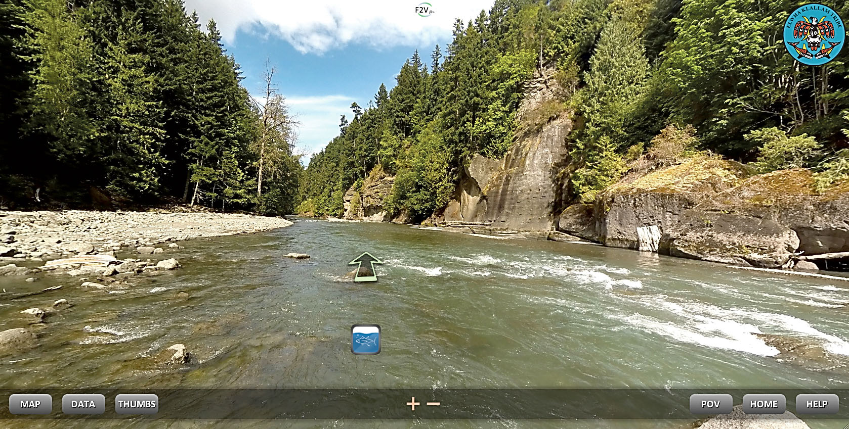
EDITOR’S NOTE: Here is an example of a section of the online tour upstream of the former Elwha Dam. Click on the image and move your mouse to look around. Click on the arrow to move down the river. Click on the fish to look under the water.
CLICK ON: http://f2v.me/tours/elwha/tour-lake-aldwell2.html#/scene_elwha_01500/
FOR MORE TOURS and further information: http://f2v.me/news-and-events-elwha.html
OLYMPIC NATIONAL PARK — Anyone with a computer or mobile device can take a virtual ride on the Elwha River from the former Lake Mills to the mouth as the river empties into the Strait of Juan de Fuca.
Users of the Google Street View-style project by Flying Fish Views, a Seattle-based startup also known as F2V, can see rapids and even dive underwater to see the “fish view” version of the trip.
The “travel” is via 30,000 individual photographs stitched together to create a 360-degree view of the lower third of the river and valley around a river raft.
The trip reveals everything from underwater views of spawning salmon to towering rock overhangs as it explores the mysteries of the river now that it has been freed from two dams and is reclaiming its historical route through steep valleys and narrow canyons.
The Elwha River, with its national audience and ground-breaking ecological restoration, seemed like a natural choice for the very first mapping project by Flying Fish Views, said Scott Gallagher, co-founder and director of business development.
“It’s a logical place to start,” he said.
Internet and mobile device users can go to www.f2v.me and select the Elwha River to begin their trips down the river.
The trip can be viewed on HTML 5 on updated browsers and devices, said Brian Footen, president of Flying Fish Views. A Flash plug-in is required for older systems, he added.
Use of the site is free during development, and the main element of the site — the 360-degree view of the trip down the river — will remain free if and when the developers choose to add premium pay-per-use elements to the site.
To use the site, “grab” onto the image with the mouse and move the picture around just like Google Street View.
Click on the arrow to move up or down the river, or click on the fish icon to see the underwater view.
Direct links bring viewers to some of the highlights of the trip, including a close-up view of a spawning salmon and a dramatic rock ledge overhang in the narrow Elwha Canyon where Elwha Dam held back river waters for 100 years.
The 108-foot Elwha Dam, completed in 1913, and the 210-foot Glines Canyon Dam, built in 1927, were removed by demolition crews beginning in 2011 as part of a $325 million project to restore the more than 70 miles of salmon habitat.
Built without fish ladders, the two dams blocked salmon from all but the lowest 5 miles of river habitat, reducing runs of as many as 400,000 salmon per year to only a few thousand.
They also held back an estimated 34 million cubic yards of sediment, trapped behind the two dams.
River currents scoured fine sediments and gravels out of the main riverbed, and carved a deep, smooth channel with deep pools, without the gravel beds and sand bars required by the salmon and other spawning fish.
The sediment that has reshaped the river, reforming gravel bars, and sand washed downstream have built an estimated 80 acres of beaches at the mouth of the Elwha River on the Strait of Juan de Fuca.
The F2V project was photographed in August using a specially equipped inflatable river raft with a set of waterproof high-definition cameras, including one underwater.
Project members took the trip in three sections, photographing the river for a 360-degree view, according to Footen.
“We started it within 48 hours after the last of the Glines Canyon Dam came down,” Footen said.
Team members began at the southern end of the former Lake Mills and rafted to the river mouth.
Their photography includes portage when large logs blocked the river channel and when Class III rapids at the former Elwha Dam site proved too narrow for the raft and too violent for the photographic equipment, he said.
While the technology is based on the Google Street View system, it is a brand-new system “marine environment” design by the F2V team.
The Google camera system is too heavy, too bulky and not suitable to put in a river, so the team designed its own 360-degree camera system over the past 20 months, Footen said.
The system they call “FishViews” is captured through high-definition photography on, over and under the water, and fused with concurrent measurements of the physical properties of the waterway — all synchronized by time and location.
“It has small, durable elements,” Footen said.
Footen is a fishery research scientist who has worked for federal, state and tribal agencies, and for the F2V project is working in cooperation with the U.S. Park Service, the Lower Elwha Klallam tribe, the U.S. Geological Survey and other agencies to document the river’s transformation.
He has master’s degrees in fishery science and environmental science from the University of Washington and Evergreen State College, respectively.
Until recently, the camera system developed by F2V was a prototype designed by its technical team of Scott Goodwin, Rob Crampton and Isaac Peachin.
“It’s out of prototype and into the beta testing phase,” Gallagher said.
Gallagher is a former U.S. Navy aviator and has held vice president and director-level positions in private business, state and municipal governments.
He and other founders of Flying Fish Views eventually intend to cover the entire 45 miles of the Elwha River, from its source near Mount Olympus to the Strait.
And the team plans to return to the river in the future to map the changes wrought by the winter rains.
“It will establish trend lines to see what’s going to happen over time,” he said.
He said those who use the system will be able to compare the 2014 version with the 2015 or future versions, side-by-side, to show how much the river has changed with each storm season.
Footen said this year’s effort will include more trips as part of a larger project in cooperation with the National Park Service and USGS.
F2V also plans to map other Strait of Juan de Fuca and Puget Sound rivers in the spring and summer, he said.
The company recently completed mapping Spring Lake, located in San Marcos, Texas, an iconic lake fed by more than 200 natural underwater springs originating from the Edwards Aquifer.
Spring Lake is believed to be one of the longest continually inhabited sites in North America.
Archaeological evidence indicates 12,000 years of human habitation at the lake.
Questions and comments are welcome at brian@flyingfishviews.com.
“We’d love to get feedback,” Footen said.
________
Reporter Arwyn Rice can be reached at 360-452-2345, ext. 5070, or at arice@peninsuladailynews.com.
