Joe Smillie/Department of Natural Resources

Joe Smillie/Department of Natural Resources

Tsunami walking evacuation map released

DNR also has created routes for population centers

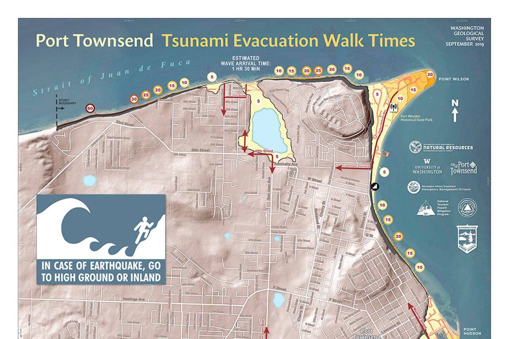
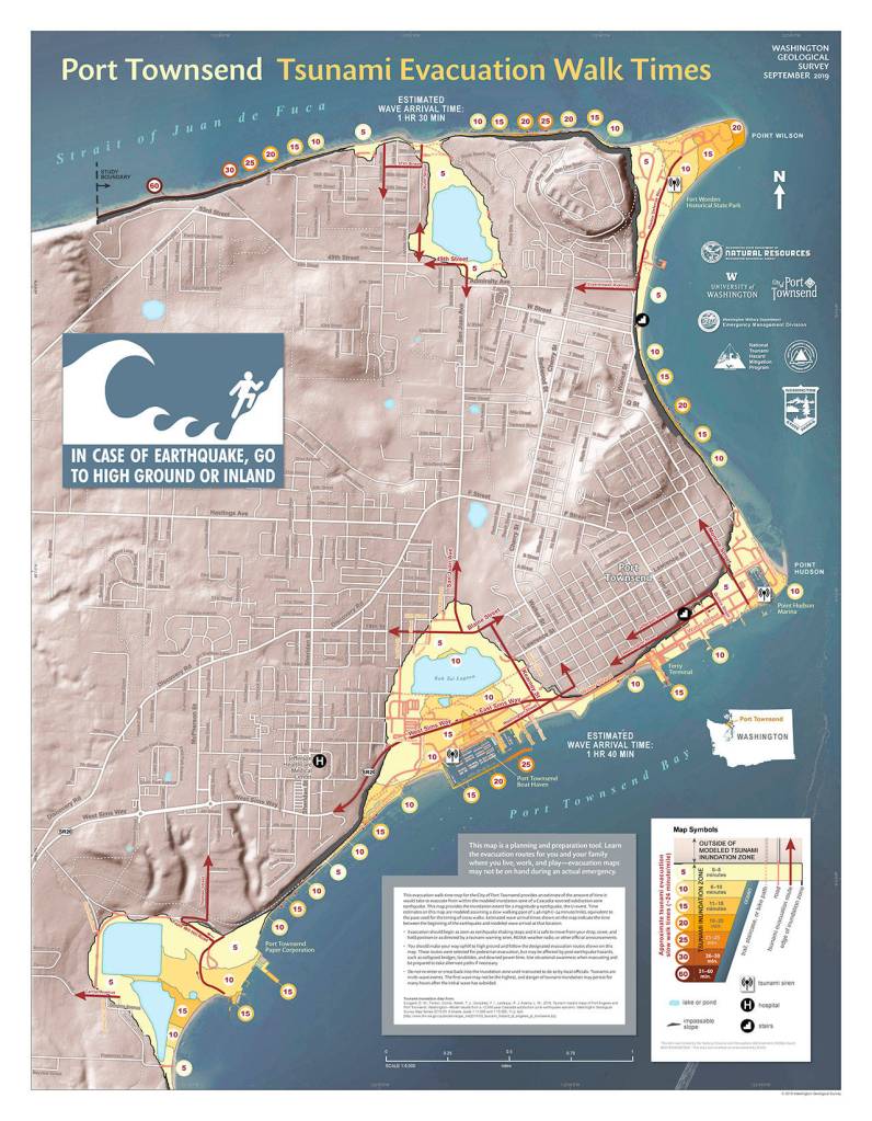
PORT TOWNSEND — The state Department of Natural Resources released last week a Port Townsend tsunami evacuation route map that shows the amount of time needed to walk out of a threatened area.

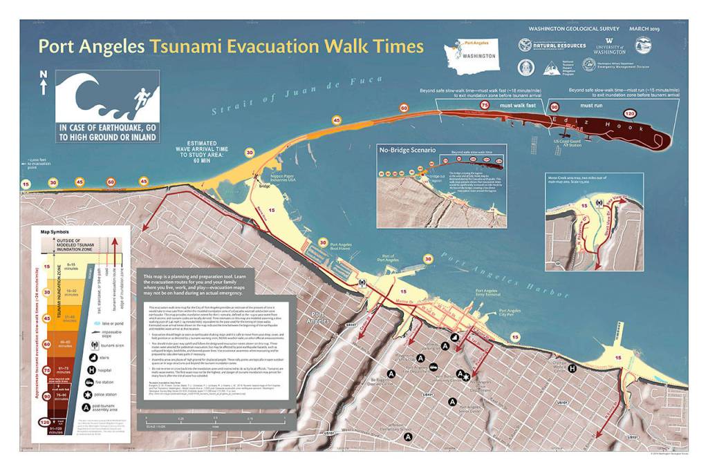
A similar map for Port Angeles was released in April, and video simulations were released by the state in August.

The map shows the time it would take to evacuate on foot from the tsunami inundation zones caused by a Cascadia subduction zone earthquake.

The Department of Natural Resources (DNR) has been compiling these maps for low-lying areas that are at risk of tsunamis for cities around the state’s western coast such as Long Beach and Westport.

More maps are being compiled, said Joe Smillie, communications director for DNR.

“We’re working on the others,” Smillie said. “But we’re focusing on the population centers.”

So far the complete list of walking evacuation maps include:

• Port Angeles

• Bellingham

• Anacortes

• Aberdeen

• Hoquiam

• Cosmopolis

• Port Townsend

• Ilwaco and Cape Disappointment

• Long Beach and Seaview

• Westport

The maps are color coded to indicate how many minutes it would take to walk safely from the inundation zone.

Joe Smillie/Department of Natural Resources

Joe Smillie/Department of Natural Resources

For Port Townsend, it can take anywhere from five minutes to an hour to walk to safety.

In Port Angeles, it is estimated to take anywhere from 15 minutes to two hours if on Ediz Hook (where the map recommends running instead of walking) to exit the inundation zone.

“We’ve seen around the world how devastating tsunamis are for coastal communities,” Hilary Franz, public lands commissioner and elected leader of DNR said in a press release.

“In the event of a tsunami, nothing is more important than knowing where to go and how long it will take to get there.

“That is why [DNR’s] geologists are making this live-saving information easily available for everyone who lives, works or plays along the Washington Coast.”

It has been 319 years since Cascadia last had a major earthquake, which in 1700 caused a tsunami to hit all of the Pacific Northwest and traveled to Japan, according to DNR.

The maps are modeled on a 9.0 magnitude earthquake, by using the models of larger Cascadia events to a provide a scenario that will be useful for smaller events as well, according to DNR.

The Cascadia subduction zone is an offshore area where the Juan de Fuca tectonic plate is pulled under the North American plate, and produces “megathrust quakes” every 300 to 600 years, DNR said.

The maps can be found online at tinyurl.com/PDN-tsunamiwalkingmaps.

________

Jefferson County reporter Zach Jablonski can be reached at 360-385-2335, ext. 5 or at zjablonski@peninsuladailynews.com.

More in News

Peninsula College to continue without budget

Board expects plan in September

An Olympic marmot stands as the star of the show at Hurricane Ridge on Monday. These tourists from Alaska stopped and photographed the creature from a distance as he slowly ate his meal of wildflowers. The marmot is a rodent in the squirrel family and is unique to Washington state. The hibernating mammal’s burrow is only about 50 feet up the paved path away from the parking lot. The group had just photographed deer at the Ridge. (Dave Logan/for Peninsula Daily News)
Olympic marmot

An Olympic marmot stands as the star of the show at Hurricane… Continue reading

Eighth-graders Saydey Cronin and Madelyn Bower stand by a gazebo they and 58 other students helped to build through their Sequim Middle School Core Plus Instruction industrial arts class. The friends were two of a handful of girls to participate in the building classes. (Matthew Nash/Olympic Peninsula News Group)
Middle school students build gazebo for academy

Businesses support project with supplies, flooring and tools

Frank Nicholson and David Martel.
Veterans in Warrior Bike program to pass through Peninsula towns

Community asked to welcome, provide lodging this summer

Special Olympian Deni Isett, center, holds a ceremonial torch with Clallam County Sheriff Brian King, right, accompanied by Lt. Jim Thompson of the Lower Elwha Klallam Tribal Police on a leg of the Law Enforcement Torch Run on the Olympic Discovery Trail at Port Angeles City Pier. Tuesday’s segment of the run, conducted mostly by area law enforcement agencies, was organized to support Special Olympics Washington and was to culminate with a community celebration at 7 Cedars Casino in Blyn. (Keith Thorpe/Peninsula Daily News)
Carrying the torch

Special Olympian Deni Isett, center, holds a ceremonial torch with Clallam County… Continue reading

Hopefuls for Olympic Medical Center board debate

Talk focuses on funds, partnership

An encapsulated engineered coupler used to repair a January leak. The leak occurred along a similar welded joint near to the current leak. (City of Port Townsend)
Port Townsend considers emergency repair for pipeline

Temporary fix needs longer-term solution, officials say

Traffic to be stopped for new bridge girders

Work crews for the state Department of Transportation will unload… Continue reading

The Peninsula Crisis Response Team responded with two armored vehicles on Tuesday when a 37-year-old Sequim man barricaded himself in a residence in the 200 block of Village Lane in Sequim. (Clallam County Sheriff’s Office)
Man barricaded with rifle arrested

Suspect had fired shots in direction of deputies, sheriff says

An interior view of the 12-passenger, all-electric hydrofoil ferry before it made a demonstration run on Port Townsend Bay on Saturday. Standing in the aisle is David Tyler, the co-founder and managing director of Artemis Technologies, the designer and builder of the carbon fiber boat. (Steve Mullensky/for Peninsula Daily News)
Demonstration provides glimpse of potential for ferry service

Battery-powered hydrofoil could open water travel

Electronic edition of newspaper set for Thursday holiday

Peninsula Daily News will have an electronic edition only… Continue reading

Juliet Shidler, 6, tries on a flower-adorned headband she made with her mother, Rachel Shidler of Port Angeles, during Saturday’s Summertide celebration in Webster’s Woods sculpture park at the Port Angeles Fine Arts Center. The event, which marks the beginning of the summer season, featured food, music, crafts and other activities for youths and adults. (Keith Thorpe/Peninsula Daily News)
Summertide festival

Juliet Shidler, 6, tries on a flower-adorned headband she made with her… Continue reading