Get ready for some rough weather [UPDATES with wind, flood warnings, more]
Published 12:01 am Saturday, December 15, 2012
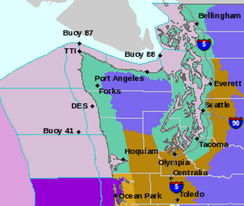
A series of warnings and advisories have been issued by the National Weather Service to prepare North Olympic Peninsula residents for a storm approaching late Sunday into Monday.
Meanwhile, Hurricane Ridge Road — and the visitor center atop the mile-high snow play area — will be closed Sunday because of snow and heavy winds, Olympic National Park reports. http://www.nps.gov/olym/planyourvisit/hurricane-ridge-current-conditions.htm
Follows are statements and advisories from the National Weather Service:
COASTAL HAZARD MESSAGE
NATIONAL WEATHER SERVICE SEATTLE WA
202 PM PST SAT DEC 15 2012
…TIDAL OVERFLOW AND COASTAL FLOODING ARE POSSIBLE MONDAY…
.A STRONG LOW PRESSURE SYSTEM WILL MOVE THROUGH WESTERN WASHINGTON
MONDAY MORNING. HIGH TIDES AND BIG WAVES MAY PRODUCE TIDAL
OVERFLOW AND FLOODING NEAR THE BEACHES…
WAZ001-503-506>511-514-515-161230-
/O.NEW.KSEW.CF.A.0006.121217T1400Z-121217T1800Z/
SAN JUAN COUNTY-WESTERN WHATCOM COUNTY-WESTERN SKAGIT COUNTY-
EVERETT AND VICINITY-SEATTLE/BREMERTON AREA-TACOMA AREA-
ADMIRALTY INLET AREA-HOOD CANAL AREA-
EASTERN STRAIT OF JUAN DE FUCA-WESTERN STRAIT OF JUAN DE FUCA–
202 PM PST SAT DEC 15 2012
…COASTAL FLOOD WATCH IN EFFECT FOR MONDAY MORNING…
THE NATIONAL WEATHER SERVICE IN SEATTLE HAS ISSUED A COASTAL
FLOOD WATCH…WHICH IS IN EFFECT MONDAY MORNING.
* HAZARD…WAVES AND TIDAL ANOMALY AT HIGH TIDE.
* IMPACTS…TIDAL OVERFLOW AND FLOODING NEAR THE BEACHES.
* TIME OF HIGH TIDE…8 OR 9 AM.
* TIDE TABLE PREDICTION…12.9 FT SEATTLE…9.7 FT PORT
TOWNSEND…10.5 FT CHERRY POINT.
* EXPECTED TIDAL ANOMALY…1 TO 2 FEET.
PRECAUTIONARY/PREPAREDNESS ACTIONS…
A COASTAL FLOOD WATCH MEANS FLOODING OR BEACH EROSION WILL OCCUR
IF WEATHER CONDITIONS DEVELOP AS PREDICTED. RESIDENTS AND LOCAL
OFFICIALS SHOULD MONITOR THE SITUATION CLOSELY AND BE PREPARED TO
TAKE APPROPRIATE ACTION IF A WARNING IS ISSUED.
———–
URGENT – WEATHER MESSAGE
NATIONAL WEATHER SERVICE SEATTLE WA
153 PM PST SAT DEC 15 2012
…A STRONG LOW PRESSURE SYSTEM WILL BRING A THREAT OF HIGH WINDS
TO WESTERN WASHINGTON FROM LATE SUNDAY AFTERNOON THROUGH MONDAY
MORNING…
.A 975 MB SURFACE LOW IS EXPECTED TO DEVELOP OFF THE COAST OF
WASHINGTON ON SUNDAY. LATEST COMPUTER MODELS INDICATE THE LOW
CENTER WILL MOVE ONTO THE WASHINGTON COAST EARLY MONDAY MORNING.
THE EXACT TRACK OF THE SURFACE LOW REMAINS SOMEWHAT UNCERTAIN AND
WILL HAVE A BIG IMPACT ON WHERE HIGH WINDS DEVELOP. THERE IS
ENOUGH CERTAINTY THAT AT LEAST A PORTION OF WESTERN WASHINGTON
WILL EXPERIENCE HIGH WINDS…THEREFORE A HIGH WIND WATCH HAS BEEN
ISSUED.
WAZ514-515-160600-
/O.NEW.KSEW.HW.A.0009.121217T0800Z-121217T2000Z/
EASTERN STRAIT OF JUAN DE FUCA-WESTERN STRAIT OF JUAN DE FUCA–
153 PM PST SAT DEC 15 2012
…HIGH WIND WATCH IN EFFECT FROM LATE SUNDAY NIGHT THROUGH
MONDAY MORNING…
THE NATIONAL WEATHER SERVICE IN SEATTLE HAS ISSUED A HIGH WIND
WATCH…WHICH IS IN EFFECT FROM LATE SUNDAY NIGHT THROUGH MONDAY
MORNING.
* SOME AFFECTED LOCATIONS…PORT ANGELES…AND SEKIU.
* TIMING…WEST WINDS WILL RISE BEHIND A STRONG LOW PRESSURE
SYSTEM LATE SUNDAY NIGHT AND MONDAY MORNING.
* WIND…WEST WINDS 30 TO 40 MPH WITH GUSTS TO 60 MPH.
* IMPACTS…WINDS THIS STRONG CAN TOPPLE TREES…DOWN POWER
LINES…AND DAMAGE SOME STRUCTURES.
PRECAUTIONARY/PREPAREDNESS ACTIONS…
A HIGH WIND WATCH MEANS THERE IS THE POTENTIAL FOR A DAMAGING
WIND EVENT.
—————–
URGENT – WINTER WEATHER MESSAGE
NATIONAL WEATHER SERVICE SEATTLE WA
149 PM PST SAT DEC 15 2012
WAZ513-518-519-160630-
/O.NEW.KSEW.WS.A.0018.121216T2000Z-121218T1200Z/
/O.CON.KSEW.WW.Y.0043.000000T0000Z-121216T2000Z/
OLYMPICS-WEST SLOPES NORTHERN CASCADES AND PASSES-
WEST SLOPES CENTRAL CASCADES AND PASSES-
149 PM PST SAT DEC 15 2012
…WINTER WEATHER ADVISORY REMAINS IN EFFECT UNTIL NOON PST
SUNDAY…
…WINTER STORM WATCH IN EFFECT FROM SUNDAY AFTERNOON THROUGH
LATE MONDAY NIGHT…
THE NATIONAL WEATHER SERVICE IN SEATTLE HAS ISSUED A WINTER STORM
WATCH…WHICH IS IN EFFECT FROM SUNDAY AFTERNOON THROUGH LATE
MONDAY NIGHT.
* SOME AFFECTED LOCATIONS…SNOQUALMIE PASS…STEVENS PASS…
MOUNT BAKER…WHITE PASS…PACKWOOD…INDEX…SKYKOMISH…AND
NEWHALEM.
* TIMING…SNOW WILL BE HEAVY AT TIMES THROUGH SUNDAY MORNING. A
LULL IN PRECIPITATION IS EXPECTED MIDDAY SUNDAY. ANOTHER
STRONGER STORM WILL BRING RENEWED HEAVY SNOW FROM SUNDAY
AFTERNOON THROUGH LATE MONDAY NIGHT.
* SNOW ACCUMULATIONS…TOTAL SNOW ACCUMULATIONS OF 8 TO 16 INCHES
ARE EXPECTED WITH THIS FIRST STORM SYSTEM BY LATE SUNDAY
MORNING. A SECOND STRONGER STORM WILL PRODUCE AN ADDITIONAL 1.5
TO 3 FEET FROM LATE SUNDAY AFTERNOON THROUGH LATE MONDAY NIGHT.
* MAIN IMPACT…VERY STRONG WESTERLY WINDS OVER 40 MPH ARE
EXPECTED TO DEVELOP ON MONDAY. THIS WILL CAUSE SIGNIFICANT
BLOWING AND DRIFTING OF SNOW…AND VERY POOR VISIBILITY. EXPECT
WINTER DRIVING CONDITIONS TONIGHT THROUGH LATE MONDAY NIGHT.
* SNOW LEVEL…2000 FEET OR LOWER AFFECTING ALL PASSES.
PRECAUTIONARY/PREPAREDNESS ACTIONS…
A WINTER WEATHER ADVISORY IS ISSUED FOR A VARIETY OF WINTER
WEATHER CONDITIONS SUCH AS FREEZING RAIN AND SNOW OCCURRING AT
THE SAME TIME. WHILE THE WEATHER WILL BE SIGNIFICANT…THE WORD
ADVISORY MEANS THAT LIFE THREATENING WINTER WEATHER IS NOT
EXPECTED.
FOR ROAD CONDITIONS OR TRAVEL ALERTS…CALL 5-1-1 OR 1-800-695-
7623…OR VISIT WWW.WSDOT.WA.GOV.
A WINTER STORM WATCH MEANS CONDITIONS ARE FAVORABLE FOR SEVERE
WINTER WEATHER. IF YOU MUST TRAVEL IN THE WATCH AREA…CARRY AN
EXTRA FLASHLIGHT…FOOD…WATER…AND BLANKETS IN CASE OF
EMERGENCY.
Avalanche Watch
WAZ513-518-519-019-ORZ011-162000-
…AVALANCHE WATCH FOR THE OLYMPICS AND WASHINGTON CASCADES NEAR AND
WEST OF THE CREST AND MT HOOD AREA FOR SUNDAY NIGHT AND MONDAY…
STRONG WINDS AND INCREASING SNOW SHOULD BEGIN IN THE OLYMPICS AND
CASCADES AS THE FRONT APPROACHES SUNDAY AFTERNOON. WESTERLY
OROGRAPHIC FLOW AND HEAVY SNOW SHOULD FOLLOW THE FRONT AND THE
STRONG SURFACE LOW PRESSURE SYSTEM SUNDAY NIGHT AND MONDAY.
WINDS…HEAVY SNOW… RAPID LOADING…TEMPORARY WEAK STORM
LAYERS…PREVIOUS LOW DENSITY LAYERS AND CRUSTS SHOULD ALL HELP TO
CAUSE DEEP NEW WIND AND STORM SLAB LAYERS AND A HIGH AVALANCHE
DANGER BY SUNDAY NIGHT. THESE CONDITIONS SHOULD BE SEEN IN THE
OLYMPICS AND CASCADES FROM MT BAKER TO MT HOOD. AN AVALANCHE WATCH
IS IN EFFECT FOR SUNDAY NIGHT AND MONDAY.
THIS STATEMENT WILL UPDATED AS WARRANTED. PLEASE VISIT WWW.NWAC.US
FOR HOURLY WEATHER DATA AND FORECAST DETAILS.
For updates and details, go to the National Weather Service-Seattle website at http://www.wrh.noaa.gov/sew.


