New maps project tsunamis hitting Port Angeles, Port Townsend
Published 1:30 am Monday, August 27, 2018


The state Department of Natural Resources’ latest version of its Tsunami Inundation Hazard Map posits a wall of water that is up to 21 feet high racing down the Strait of Juan de Fuca after a magnitude 9 earthquake in the Cascadia Subduction Zone.
“The maps are based on a different scenario than previous ones,” said Willie Bence, Jefferson County Department of Emergency Management director after the new maps were released earlier this month.
“It is the worst-case scenario, worse than the 1700 Cascadia Subduction Quake, the last one we have on record. Fifty feet above sea level remains the safe point for tsunami evacuation. These maps haven’t changed that recommendation.”
The Cascadia Subduction Zone fault is located off the northwest coast, stretching from northern Vancouver Island south along the Washington and Oregon coasts to Cape Mendocino in California.
Based on the geological record and written accounts from Japan, the last major Cascadia quake occurred Jan. 26, 1700. Geologists say it is not a matter of if, but when the next big one strikes the 600-mile-long subduction zone off the Northwest coast.
On Wednesday, a magnitude 6.2 quake occurred Wednesday on the Cascadia fault line 220 miles southwest of Portland, Ore, a 3.5 magnitude aftershock. There were no reports of damage.
In the event of a magnitude 9 Cascadia earthquake, DNR projects the sea level would drop approximately 6.5 feet before the first tsunami waves arrive along the Strait of Juan de Fuca.
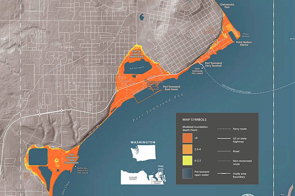
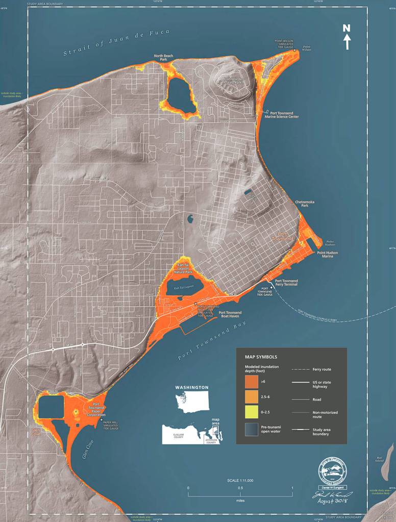
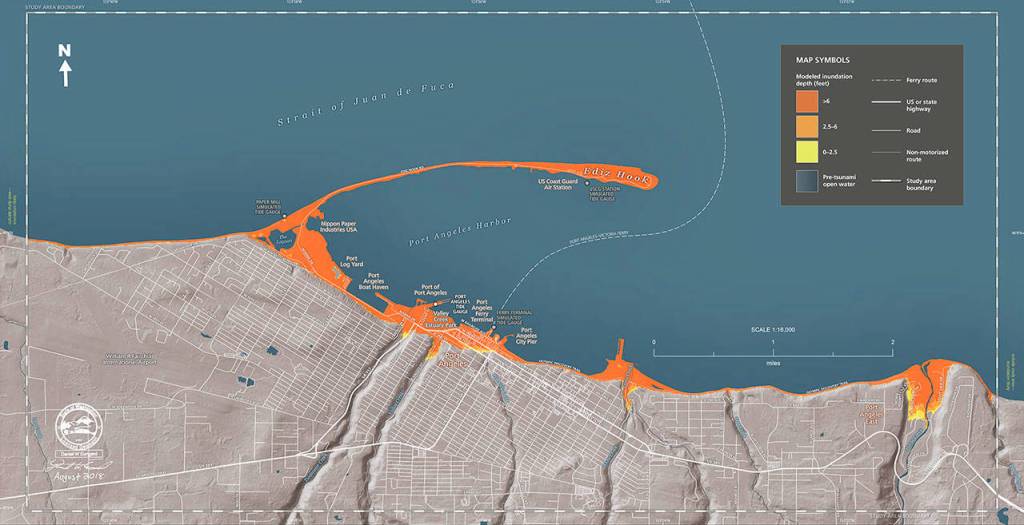
The first wave is expected to be as high as 21 feet, reaching Port Angeles within 60 minutes of the quake and Port Townsend within 100 minutes.
The velocity of the waves would be 26 knots (30 mph). Certain topographic features would produce strong currents with potential for the formation of vortexes. Examples of these are Ediz Hook, Point Wilson and Point Hudson.
Tsunami inundation would continue for eight hours, and hazardous conditions would remain for more than 24 hours, according to DNR.
The Quimper Peninsula would be seriously affected by such an event. Bence said the areas to be concerned about the most include the commercial core in Port Townsend where most of the services are located.
The map indicates the most vulnerable shoreline areas to be from Old Fort Townsend Road and the Glen Cove area north past the Port Townsend Paper Mill, continuing along the waterfront through Boat Haven and along Sims Way to the ferry terminal.
The downtown core would be affected along Water Street to Point Hudson and from Monroe Street and Chetzemoka Park on the eastern shoreline stretching all the way to Point Wilson Lighthouse and Fort Worden, then west including the North Beach area to Cook Avenue.
Jamye Wisecup, Clallam County Emergency Management program coordinator, said, “Any shaking for a minute or more should be considered your warning sign to “drop, cover, and hold” until the shaking stops and then take your safest evacuation route and keep a steady pace to the get up above the inundation zones on the newly released maps.”
Indications at the Valley Creek area show the inundation moving above Sixth Street. The Morse Creek inundation moves in to almost reach U.S. Highway 101.
Evacuation map
The Port Angeles evacuation map addresses the coastal geography to the Dry Creek waterway on the west side of Port Angeles to the Bagley Creek waterway on the east side of Port Angeles. It extends north to encompass Ediz Hook and south to Lauridsen Boulevard.
Wisecup said Clallam County continues to grow in the number of Amateur Radio Emergency Services operators, Map Your Neighborhood teams, Community Emergency Response Teams, Community Points of Distribution Teams, and other teams for response and recovery. People who are trained with these teams also will be valuable assets at assembly areas, transportation exchange sites, and shelter sites that will be helping with community members and visitors displaced by the evacuation.
Bence said his team is working to secure assistance before the disaster happens.
“Here at Jefferson County Emergency Management, when we work with our emergency agencies, we are doing the best we can to plan to bring help into the area,” Bence said.
“Whether it’s working with the National Guard or the Navy, we are trying to get supplies in. We’re working with private and volunteer pilots, too.
“Jefferson County International Airport is centralized and not everyone will be able to get there,” he said.
“We’re looking at seaplanes, looking at landing planes on stretches of highway that meet certain criteria, any way we can improvise to get people and supplies in an out.”
A Cascadia event would be most likely the largest regional emergency in U.S. history, Bence said.
“It will be on the scale of a Katrina or a Sandy. It will be chaos, it will be miserable.
“But the more you can do at a personal level to prepare yourself and your family and to go out and work with your neighbors, the better off you are going to be. Your personal emergency plan should not be dependent on getting to a grocery store, a hardware store or a gas station.”
The new DNR tsunami maps can be accessed at https://tinyurl.com/PDN-tsunamimaps.
For more information about getting connected with your neighborhood in Jefferson County, see https://l2020.org/emergency-preparedness/.
Both counties now offer CERT (Community Emergency Response Team) training. Students learn triage and treatment, first aid, light fire suppression and light search and rescue skills. It’s a nationwide program, recognized by the Federal Emergency Management Agency (FEMA).
The Clallam County Emergency Management website at www.clallam.net/emergencymanagement/ has links to CERT training and other emergency preparedness information.
To contact the Jefferson County Department of Emergency Management regarding CERT training — which became available in Jefferson County earlier this year — emergency preparation information or volunteer opportunities, call 360-385-9368. or visit https://www.co.jefferson.wa.us/950/Dept-of-Emergency-Management.
________
Jefferson County Editor/Reporter Jeannie McMacken can be reached at 360-385-2335 or a jmcmacken@peninsuladailynews.com

Best of Olympic Peninsula