Lake Crescent is seen from Mount Storm King on Friday, May 22, 2020. (Rob Ollikainen/Peninsula Daily News)

Lake Crescent is seen from Mount Storm King on Friday, May 22, 2020. (Rob Ollikainen/Peninsula Daily News)

Storm King trail among those now open

Olympic National Park allows hiking with proper social distancing

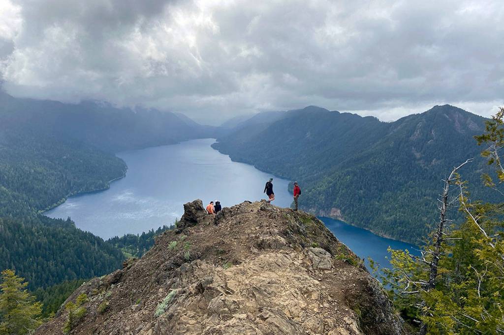
OLYMPIC NATIONAL PARK — A bird’s-eye view of Lake Crescent awaits on the craggy flanks of Mount Storm King.

A prominent overlook more than 2,000 feet above the crystal-clear water offers a panoramic perspective of this glacially-carved jewel of the North Olympic Peninsula.

Expect to have some company on this classic Northwest hike as Storm King remains popular with locals and visitors alike.

Alex Atmore of Seattle uses a fixed rope to arrest his descent down the Storm King trail. (Rob Ollikainen/Peninsula Daily News)

Alex Atmore of Seattle uses a fixed rope to arrest his descent down the Storm King trail. (Rob Ollikainen/Peninsula Daily News)

After a two-month closure for COVID-19 precautions, Olympic National Park reopened portions of its million-acre wilderness May 15, including the Lake Crescent area.

West End beaches, the Hoh River and Hurricane Ridge remain closed.

At least three dozen hikers practiced social distancing on the Marymere Falls/Storm King trail last Friday afternoon. None were in groups of more than five, and all made room to pass safely.

Public health officials say hiking is appropriate amid the COVID-19 pandemic as long as you abide by physical-distancing restrictions.

A chain leads the way up Mount Storm King. (Rob Ollikainen/Peninsula Daily News)

A chain leads the way up Mount Storm King. (Rob Ollikainen/Peninsula Daily News)

Dr. Anthony Fauci, the nation’s top infectious disease expert, said he planned to go hiking on Memorial Day weekend, too, so we were in good company.

The steep, unrelenting route up Mount Storm King leaves the Marymere Falls nature trail about a half-mile from the parking lot. No special permits are required to park. Dogs are not allowed on the trail.

The Storm King trail is covered by old growth canopy until you gain a ridgeline — and the first views of Lake Crescent — at about 2,000 feet of elevation.

At 2,400 feet, you’ll see a sign bolted to a tree that says “End of maintained trail.”

You could turn around here, but you’d miss all the fun.

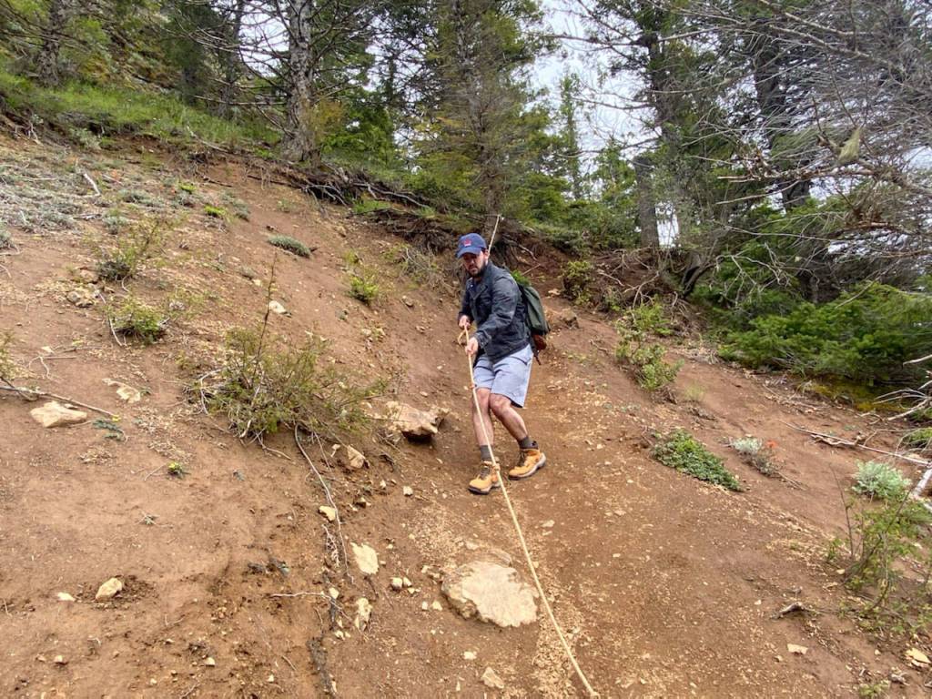
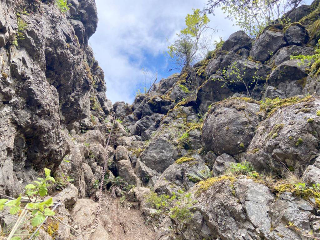
A series of fixed ropes helps hikers keep their footing on a final ascent to a 2,675-foot crag of bedrock that juts out over the ridge.

The basalt outcrop is an ideal picnic spot and generally considered to be the top of the Storm King trail.

Higher up, the ridge traverse becomes a somewhat sketchy rock scramble with more fixed ropes and a heavy chain. The true summit of Mount Storm King sits further to the east at 4,538 feet.

Lake Crescent as seen from Mount Storm King on Friday, May 22, 2020. (Rob Ollikainen/Peninsula Daily News)

Lake Crescent as seen from Mount Storm King on Friday, May 22, 2020. (Rob Ollikainen/Peninsula Daily News)

According to geologists, parts of Mount Storm King’s north face broke free in a series of landslides about 8,000 years ago.

The landslides, which originated from both sides of the valley, separated Lake Crescent from Lake Sutherland, causing the former to rise about 80 feet and moving its outflow to the Lyre River, Pacific Northwest geologist Marli Miller said in the “Roadside Geology of Washington, Second Edition.”

An Indian legend tells a similar story of the creation of Lake Crescent.

“There was much fighting between the Klallam and Quileute tribes along a small river that flowed through the present site of Lake Crescent,” according to the legend as told in an Olympic National Park brochure.

“The disagreements escalated into a great battle that lasted three days.

“The mountain spirit of the area became very upset at the foolish fighting. He hurled a gigantic boulder down at them, killing all of the warriors.

“The boulder was so big that it dammed the river and the water backed up, forming Lake Crescent.

“For many years, tribal members did not visit the area where their relatives were killed.”

Mount Storm King

■ Elevation gain: 2,075 feet.

■ Top elevation: 2,675 feet at overlook.

■ Round trip distance: 5.5 miles.

■ Directions: From U.S. Highway 101 at Lake Crescent, follow signs to Storm King Ranger Station/Marymere Falls trailhead.

________

Reporter Rob Ollikainen can be reached at rollikainen@peninsuladailynews.com.

More in Life

KEITH THORPE/PENINSULA DAILY NEWS
Cavin Vernwald of Port Angeles walks down Lincoln Street in a suit of armor on Wednesday in Port Angeles. Vernwald said  the suit was a hobby and decided that he would run errands while wearing it.
Well protected in Port Angeles

Cavin Vernwald of Port Angeles walks down Lincoln Street in a suit… Continue reading

Rally in the Alley set for Saturday

There will be a “Rally in the Alley” from 9:30… Continue reading

Vietnam vet ceremony set Wednesday

The Clallam County Veterans Association and the Michael Trebert… Continue reading

KEITH THORPE/PENINSULA DAILY NEWS
Curtains of red and green peek out from behind a bank of clouds as the aurora borealis illuminates the sky north of Port Angeles on Thursday evening. Otherwise known as the northern lights, the aurora was the result of a severe, G4-category geomagnetic storm in the Earth's atmosphere triggered by charged particles emanating from the Sun. Auroras were widely visible Thursday across Canada and northern portions of the United States. Forecasts say they might be visible tonight.
Northern lights over Peninsula

Curtains of red and green peek out from behind a bank of… Continue reading

tsr
Squatchcon offers comics, cosplay

Homegrown comic professionals to speak, offer student mentorship

KEITH THORPE/PENINSULA DAILY NEWS
Volunter Janis Burger of Port Angeles, left, plants American dune grass as Allyce Miller, revetation manage for the Lower Elwha Klallam Tribe, looks on during a planting session at a newly-restored section of beach on Ediz Hook in Port Angeles on Thursday. Nearly a dozen volunteers added their efforts to replant native grasses and other beach vegetation through a joint project of the tribe and the Clallam Conservation District.
Beach planting in Port Angeles

Volunteer Janis Burger of Port Angeles, left, plants American dune grass as… Continue reading

Photos by Karen Griffiths

Cutline:

Peninsula Junior Rodeo competitors Lillian Bond and Jasper practice Breakaway Roping (meaning she releases the rope after she throws the loop around the steer’s head instead it staying attached to her saddle horn and backing up to keep a tight connection between horse and steer)) using a “dummy” steer pulled by a Quad driven by her mom Jennifer Bond.
HORSEPLAY: Kids come join PJRA; learn the ropes, riding

CALLING ALL BUCKAROOS, cowboys and cowgirls! It’s time to saddle up and… Continue reading

A GROWING CONCERN: Take some time to mulch things over

I’VE BEEN THINKING about all the spring jobs to be done and… Continue reading

The Rev. Pam Douglas-Smith
Service set for Unity in Port Townsend

The Rev. Pam Douglas-Smith will present “Julian of Norwich’s… Continue reading

Most Read