
Possibly the coolest name for any trail anywhere is the “Overlord Trail.”
Unfortunately, Overlord also sounds kind of … dramatic.
And I wasn’t looking for any more drama.
It was named after Overlord Glacier, which is near Blackcomb Peak in British Columbia.
This was a trail I wanted to do after seeing a map of the area trails while visiting Whistler last summer. Actually, the trail I really wanted to do is called the Cloudraker Bridge on Whistler Peak, a few miles away from Blackcomb. Unfortunately, they shut that bridge down after the Labor Day Weekend. If you ever want to hike that bridge, you have to do it during the busy summer season.
So, with Cloudraker out of commission, I wanted to find something else to do when the crowds thin out at Whistler/Blackcomb and the hotel rates are insanely cheap during the shoulder season. That’s when I came across this trail called “Overlord.”
I wanted a much more positive end to the hiking season to make up for my earlier misadventures in Banff, where I got lost on the way back from a pass, took a nasty fall that cut up my wrist, lost all my water in another fall, broke my trekking pole in a third fall and ended up having to spend the night in the woods, during which I got eaten alive by mosquitoes. The only thing good that came out of that experience is that I came out of that experience.
So, I was determined this was going to be a no-drama day, even if it killed me.
Dicey weather
The trip didn’t start off promising. One of the great things about Whistler/Blackcomb in late September is that it’s fairly uncrowded and the hotel rooms are cheap. One of the not-so-great things is the weather can be dicey. And the forecast before I went on this trip kept changing from day to day — from snow flurries to 60 percent chance of rain to partly sunny. All I could do was drive up there and hope for the best. If the weather sucked … well, there are plenty of pubs and taverns in Whistler to visit.
There’s two ways you can reach Overlord. One is a very long, grueling steep hike up a trail from the town. The other is a new Blackcomb Peak Gondola that’s been around for less than a year.
The morning didn’t look promising as there was a dark, heavy cloud cover over the town when I got up in the morning. The gondola was open and running despite the weather so I figured at worst I would have an interesting gondola ride up the mountain.
I took the gondola into the white overcast and for a while was in dense fog. But, sure enough, after about 15 minutes the gondola actually climbed above the clouds. Whistler, 3,000 feet below me, was completely socked in by clouds, but the upper peaks were bright and sunny.
Overlord begins at about 5,900 feet in elevation on the upper slopes of Blackcomb. It goes steeply uphill to begin with to a little hill that tops out at 6,300 feet, but fortunately, this stretch is pretty short. For the next mile and a half, the trail actually descends quite a bit as it goes generally southward around the huge western slope of Blackcomb. Hikers get spectacular views of Whistler, Blackcomb and the massive Coast Range mountains to the west.
It was especially spectacular the day I hiked it, as the Whistler Valley continued to be socked in with clouds all day long and wisps of clouds kept blowing over the mountains. At times, I was literally hiking through cloud myself. It made for some surreal views.
I noted how much the trail seemed to be dropping and realized I would have to come back up this descent on the way back. There’s no other way to get off of the upper slopes of Blackcomb. More on that later. This looked like an easy trail on the map, but it’s not easy for this reason.
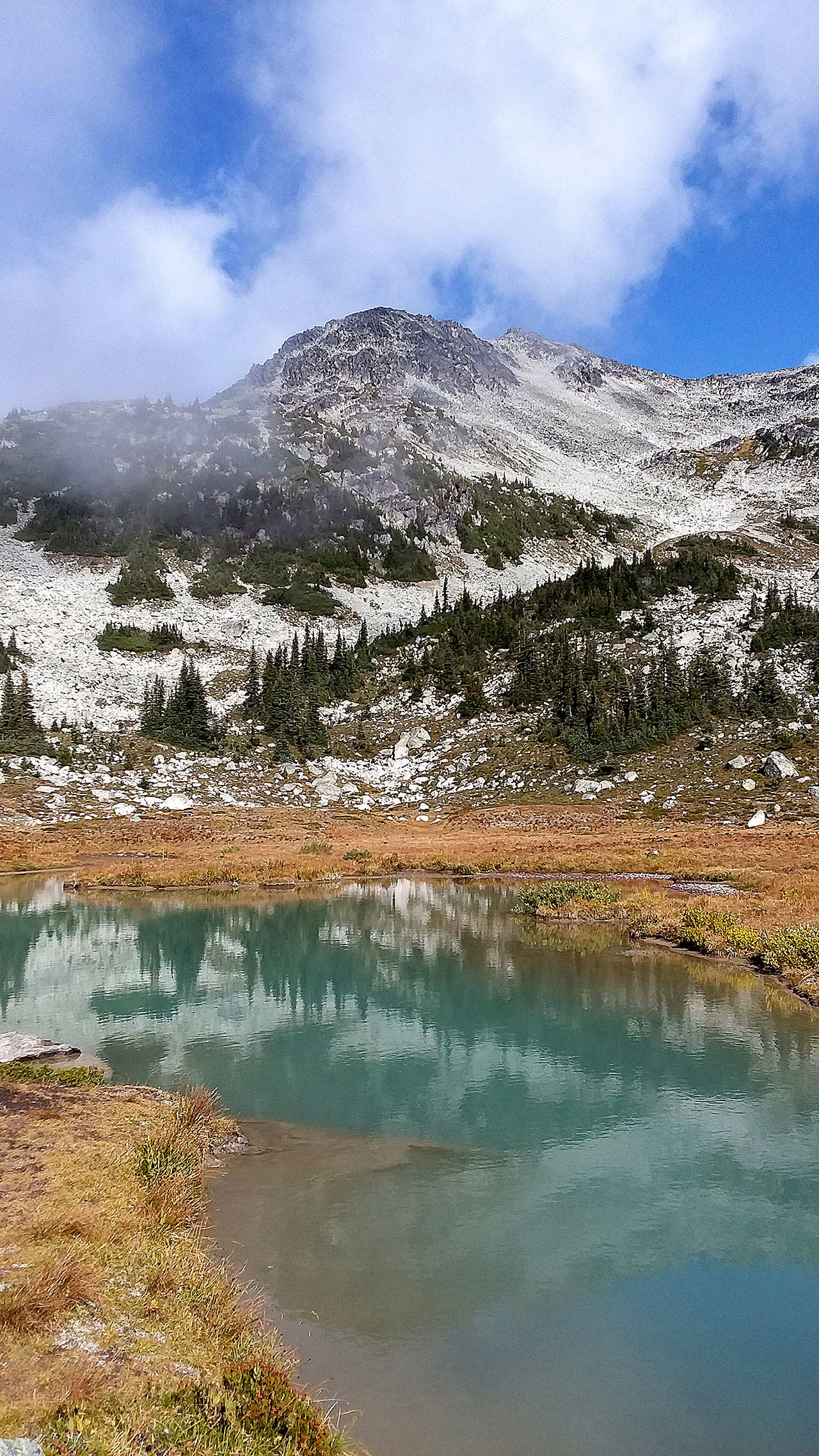
Along Overlord, there are some spur trails you can take to get closer to the peak of Blackcomb. I took a spur to a tiny lake called Blackcomb Lake right below the summit pyramid of the 7,992-foot-high mountain. This is a pretty easy spur that climbs about 300 feet and takes you to a beautiful isolated meadow.
As an aside, there was a young Italian couple hiking along the trail, and we kept passing each other literally all day. They were younger and more fit than me, but were taking their time. We must have passed each other at least six or eight times. The three of us were the only ones at Blackcomb Lake.
This spur trail drops back down pretty steeply back to Overlord. The main trail then makes its steepest climb in the whole trip as you head to a tarn on the southwestern slope of the mountain. You could take a spur up a high ridge of Blackcomb up to something called the Decker Loop, but that involved more than 700 feet of additional climbing and frankly looked really steep and I passed on it. After all, I was done with the drama the backcountry, remember? The whole day, I only witnessed five people take on the Decker Loop spur. It genuinely looked deeply intimidating … and loaded with drama.
Overlord peters out at a pretty little tarn (called Decker Tarn) at an elevation of about 6,400 feet. So, I had climbed three hills for a total of 1,100 feet of climbing to get to this spot and yet had only gained 400 feet of elevation.
There were about a dozen people at the tarn and just as many marmots scurrying around and sunning themselves on rocks. They’re pretty used to people and will walk right up to you.
I did slip on a rock and my leg went thigh-deep into the tarn, where the water couldn’t have been more than a couple of degrees above freezing.
“Ack, this feels like drama. Cold drama,” I thought.
I simply couldn’t have any more drama. Everything had to go right on this trip. I had to take my sock and shoe off and let them dry off on a rock for about an hour after which I realized it really wasn’t all that dramatic.
Here’s what makes Overlord a bit of a pain. And boy, was I ever glad I didn’t go up that Decker Loop because I would have been seriously hurting on the way back if I had.
About the final 1 1/2 miles of the trail goes steadily uphill to that little hill just past the gondola station. Normally, this wouldn’t be that difficult, but after already climbing 1,100 feet and hiking roughly six miles to get to the tarn and then back to the low point of the trail, this was a lot of work on a warm, somewhat muggy day.
I thought I was just being a wimp, letting a lot of people pass me by (including the young Italian couple, who passed me for the final time.), but I passed one guy who was literally bent over double, gasping for breath. Keep in mind, this is all happening at 6,000 feet, so you’re sucking a lot of nitrogen up there. The trail isn’t steep, but it goes relentlessly uphill for what seems forever. I swear it’s harder than hiking up Hurricane Hill. Maybe because of the mileage put in at that point.
I went at my own pace and literally said out loud, “thank God, that almost got dramatic” when I reached the top of the hill. I was completely soaked with sweat. I couldn’t believe I had brought all kinds of layers of coats and pants and long-sleeved shirts. I had climbed a total of 1,500 feet on the day on what I thought was going to be a “flat trail.”
From that point on, it was uneventful to the gondola station, where I got a celebratory beer at the cafeteria.
Finally, the clouds broke up and you could see the valley below. On the gondola ride down, I saw the biggest black bear I’ve ever seen on that grueling uphill trail. I was safely in my gondola. Pity the poor guy I saw on the trail walking right toward the bear. He was looking at more drama than me.
