Officials track slow Washington landslide near 2014 disaster

  • The Associated Press
  • Wednesday, April 12, 2017 1:30am
  • News
State geologist Dave Norman, right, and geotechnical engineer Gabe Taylor inspect the head scarp of a landslide slide on state Highway 530 near the town of Oso last Saturday. (State Department of Natural Resources via AP)

State geologist Dave Norman, right, and geotechnical engineer Gabe Taylor inspect the head scarp of a landslide slide on state Highway 530 near the town of Oso last Saturday. (State Department of Natural Resources via AP)

The Associated Press

OSO — A slow-moving landslide near the site of a mudslide that wiped out a neighbourhood and killed 43 people in 2014 has prompted officials to close a state highway as a precaution and recommend evacuations for a handful of residents, officials said.

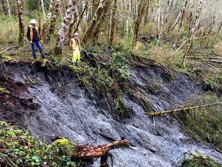
The area of the slide near the tiny community of Oso about an hour’s drive north of Seattle was being tracked by geologists Monday for ground movement. Residents of about a dozen homes were recommended by authorities to evacuate.

Landslides are common in rainy Washington state, and there have been an unusually high number of them recently following months of wet weather, said Joe Smillie, a spokesman with the state Department of Natural Resources.

Heavy recent rains probably contributed to the ground movement, authorities said. It happened in an area with a history of slides going back hundreds if not thousands of years, he said.

The location is about 1.5 miles away from the site of the March 22, 2014, mudslide that was the deadliest in U.S. history, killing 43 people.

About 270 million cubic feet of earth slid down across the Stillaguamish River, spreading out for more than half a mile.

A portion of state Highway 530 was buried under as much as 20 feet of muck and was closed for more than two months. It’s the same highway that authorities have shut down through Thursday.

The slope where the current slide is located moved about 4 feet last week between Tuesday and Saturday but has not moved since then, Smillie said.

“If the entire 24-acre slide were to give way, it could completely cover Highway 530,” the agency said in a statement Sunday. “There’s still a heightened risk that this slide could still move.”

No injuries or damage to private property has been reported, but road damage included cracks of 6 inches last Tuesday that grew to 2 feet by the weekend.

Authorities do not know whether the logging near it played a role in causing the ground movement.

The 2014 slide happened after several weeks of heavy rains, destroying a neighborhood of nearly 50 single-family homes.

A team of scientists said intense rainfall likely played a major role, but no clear cause was determined. Others factors included groundwater seeping into the slide’s mass plus changes in slope and soil weakened by previous landslides.

Smillie said there have been about 100 landslides in northwestern Washington over the past month as heavy mountain snowpack melted.

More in News

Leah Kendrick of Port Angeles and her son, Bo, 5, take a tandem ride on the slide in the playground area of the campground on Thursday at the Dungeness County Recreation area northwest of Sequim. The pair took advantage of a temperate spring day for the outdoor outing. (Keith Thorpe/Peninsula Daily News)
Tandem slide

Leah Kendrick of Port Angeles and her son, Bo, 5, take a… Continue reading

Olympic Medical Center’s losses half of 2023

Critical access designation being considered

Shellfish harvesting reopens at Oak Bay

Jefferson County Public Health has lifted its closure of… Continue reading

Chimacum High School Human Body Systems teacher Tyler Walcheff, second form left, demonstrates to class members Aaliyah LaCunza, junior, Connor Meyers-Claybourn, senior, Deegan Cotterill, junior, second from right, and Taylor Frank, senior, the new Anatomage table for exploring the human body. The $79,500 table is an anatomy and physiology learning tool that was acquired with a grant from the Office of the Superintendent of Public Instruction and from the Roe Family Endowment. (Steve Mullensky/for Peninsula Daily News)
Jefferson Healthcare program prepares students for careers

Kids from three school districts can learn about pathways

Court halts watershed logging

Activists block access to tree parcels

FEMA to reduce reimbursement eligibility

Higher thresholds, shorter timeframes in communities

Eighty-eight hopefuls file for public office

Candidate filing week ends today

Gov. Bob Ferguson addresses the crowd at the Upper Hoh Road washout repair on Thursday afternoon. Local officials, business owners, contractors, workers from the Jefferson County Public Works department and a few individuals who donated funds to the project stand behind him. Before the ribbon was cut and the road officially opened, there were short statements from involved parties. Ferguson said he brought his hiking boots and joked that he wanted to be the first one to hit the trail. (Christi Baron/Olympic Peninsula News Group)
Hoh Road reopens

Gov. Bob Ferguson addresses the crowd at the Upper Hoh Road washout… Continue reading

Forks man dies after tree falls at logging site

A 33-year-old Forks man died after he was struck… Continue reading

Chad Dobbs, a seasonal worker with the Port Angeles Parks and Recreation Department, smooths out a bed of wood chips on a traffic island on Tuesday in the parking lot at Port Angeles City Pier. Dobbs said the shredded wood adds a decorative touch for tourists and pier visitors. (Keith Thorpe/Peninsula Daily News)
Decorative touch

Chad Dobbs, a seasonal worker with the Port Angeles Parks and Recreation… Continue reading